NOTAMs instil fear and insecurity in drone pilots when flying an aircraft. In this article, I am going to demystify this fear of NOTAMs and express my gratitude for all the information provided on the Enaire Drones map, as it locates and guides us.
The NOTAM and the minimum distances for communicating with the Ministry of the Interior
in populated areas are the bane of many pilots’ lives, causing fear and insecurity. The truth is that once you know how to interpret it, it is very easy, and this fear disappears.
What is a NOTAM and how should it be interpreted?
A NOTAM (Notice to Airmen) is an official text notice issued by aviation authorities to report temporary airspace conditions: closures, military exercises, event restrictions, aerodrome works, etc. It does not contain colours in its original form: it is a text with codes, dates, times and vertical limits.
What is a NOTAM for drones used for?
It serves to ensure that everyone (pilots, controllers, drone operators) is aware of specific risks or limitations in the airspace and can plan their flight safely and in accordance with regulations.
How does a NOTAM for drones affect drone pilots?
This will depend largely on the distance at which the NOTAM becomes effective:
- Directly if the restriction affects the surface area (SFC) or low altitudes.
- Indirectly, if there is military activity or very low-altitude traffic near your area.
- Even if a NOTAM indicates high altitudes, you should always check the type of area (D, R, P, CTR, etc.) and the vertical limits: if it starts at SFC → you cannot fly; if it starts above your maximum flight altitude → you can usually fly, unless there are other limits.
Basic types of restrictions and prohibitions for drones that you should know about
- P (Prohibited): completely prohibited. Do not fly.
- R (Restricted): restricted; requires authorisation/coordination with the authority.
- D (Danger/Danger Area): potentially dangerous activity (e.g. military manoeuvres). It may only be active at certain times; sometimes it is limited to high altitudes. Avoid if active, even if you are officially allowed to fly within the flight limits (my recommendation).
- CTR / TMA / ATZ (controlled): areas around aerodromes; you almost always need permission or it is completely prohibited for drones.
- Temporary NOTAM: a notice with specific dates/times; it may activate any of the above zones.
Important: The map (ENAIRE Drones) colours the areas to make them easier to read (green/yellow/red), but this colour is only a visual aid, not the NOTAM itself. Red = do not fly without permission; yellow = caution; green = generally free.
How to interpret a NOTAM in practice
First of all, it is important that you familiarise yourself with the technical aeronautical abbreviations that you will encounter, such as:
- FT → Feet. This is the unit used to indicate altitude. For example: 5000 FT = 5000 feet.
- FL → Flight Level. Mainly used at cruising altitudes. It is a standardised way of measuring height based on atmospheric pressure, not directly above sea level. For example: FL180 ≈ 18,000 feet above standard pressure level (1013.25 hPa).
- AGL → Above Ground Level, i.e. above ground level.
This means that the height is measured from the ground at the point where you are, not from sea level. For example: if a NOTAM says helicopter operations at 500 FT AGL, it means that helicopters operate at 500 feet above ground level, regardless of the altitude above sea level. - AMSL → Above Mean Sea Level, i.e. above the average sea level. This indicates that the altitude is measured from sea level, not from the local terrain.
Let’s move on to explaining how to interpret a NOTAM:
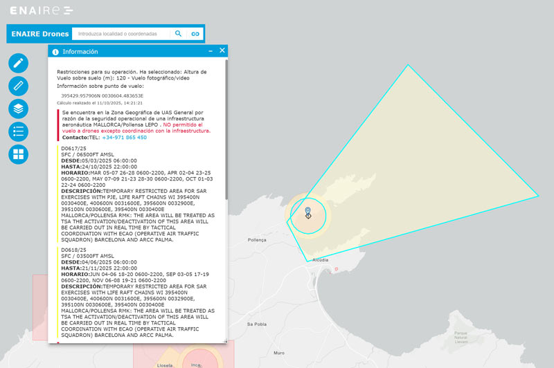
- Open ENAIRE Drones and locate your area.
- Click on the coloured area and read the entire NOTAM file, which will provide information such as: identifier, vertical limits of impact, dates and times, type (D/R/P/CTR).
- Vertical limits:
- Set SFC (surface) as the lower limit? → prohibited (do not fly).
- Is the altitude set in FT/FL/AMSL well above 120 m AGL? → You may be able to fly (see following checks).
- Check dates and times: the NOTAM may only be active for a few days or hours.
- Confirm the type of zone: if it is R/P/CTR, you need authorisation; if it is D, avoid the zone if it is active.
- Be aware of AGL vs AMSL: many NOTAMs use AMSL (metres above sea level). If you are flying in the mountains, 10,500 ft AMSL may not be that far from the local ground level; check the terrain elevation.
- If in doubt, do not fly or request authorisation; in areas near airports, contact ATC.
Practical examples of two real NOTAMs
1) FL200 / FL210 (example 1)
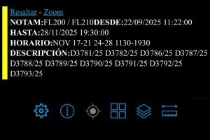
- Flight limits: from FL200 (20,000 ft) to FL210 (21,000 ft). FL200 = 20,000 ft ≈ 6,096 m; FL210 ≈ 6,400.8 m.
- Valid from: 17 to 21 November (11:30 to 19:30), 24 to 28 November (11:30 to 19:30).
- Interpretation for drones: The veto is MINIMAL or NONE for most civilian drones. The restriction begins at Flight Level 200 (FL200, which is 20,000 feet) and ends at FL210 (21,000 feet). This altitude is well above the maximum legal flight height for most drones in Spain (120 metres AGL).
- Caution: confirm with ENAIRE whether this area is marked as zone D or whether there is another overlap (CTR, R, P). If it appears ‘yellow’ and the lower limit is FL200 → ok, but maintain VLOS and respect 120 m AGL.
2) 10500 FT AMSL / UNL (example 2)
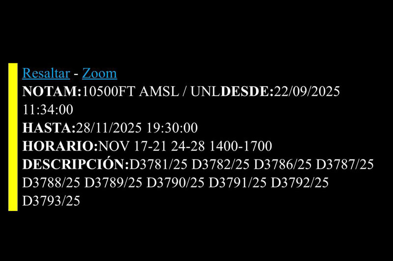
- Flight limits: 10,500 ft AMSL / UNL (Unlimited). The restriction begins at a high altitude, at ten thousand five hundred feet above sea level, and extends upwards with no altitude limit.
- Validity period: 17 to 21 November (2:00 p.m. to 5:00 p.m.), 24 to 28 November (2:00 p.m. to 5:00 p.m.).
- Interpretation for drones: DOES NOT AFFECT most civil operations. The restriction height is well above the legal flight limit for drones in Spain (120 metres AGL). The risk is ZERO for low-altitude flights.
- Extra caution: check whether AMSL is used and the elevation of the terrain where you are flying (if you are on a high mountain, calculate AGL).
3) SFC / 06500FT (FL 65) AMSL (example 3 )
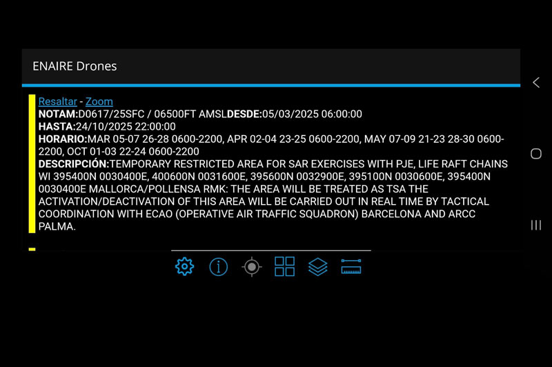
- Flight limits: SFC / 06500FT AMSL: The restriction applies from Surface (SFC) to 6500 feet above mean sea level (AMSL).
- Period of validity: 5 to 7 March (6:00 a.m. to 10:00 p.m.), 26 to 28 March (6:00 a.m. to 10:00 p.m.), 2 to 4 April (6:00 a.m. to 10:00 p.m.), 23 to 25 April (6:00 a.m. to 10:00 p.m.), 7 to 9 May (6:00 a.m. to 10:00 p.m.), 21 to 23 May (6:00 a.m. to 10:00 p.m.), 28 to 30 May (6:00 a.m. to 10:00 p.m.), 1 to 3 October (6:00 a.m. to 10:00 p.m.), 22 to 24 October (6:00 a.m. to 10:00 p.m.).
- Interpretation for drones: It is strictly prohibited to operate any type of drone (UAS) within the boundaries of the defined geographical area (Mallorca/Pollença) and between Surface (SFC) altitudes up to 6,500 feet AMSL, during the specific dates and times mentioned in the SCHEDULE section.
Now you know how to interpret a NOTAM, right? What did you think of the article? Did you find it useful?