To know where you can fly a drone in the Spanish territory I will explain you where you can NOT fly. I will tell you which are the restricted areas for drone flight in Spain.
In drone piloting it is essential that there is a perfect coexistence both in the air and on the ground, since drones are in close contact with aerial and terrestrial elements, this is the main difference that drones have with the rest of the aircrafts that circulate in the air.
“Where can you fly a drone?“, you might be asking yourself this question over and over again if lately you have in mind the idea of buying a drone to get into the exciting aeronautical world.
La forma más fácil de saber dónde volar un dron es consultar el mapa de Enaire Drones.
Once inside the website you must choose the type of operation you are going to do (recreational or professional), select the point where you want to fly and you will automatically see on the map if you can fly freely or if you have flight restrictions and which ones, through marks on the map and a ‘floating’ information box that appears on the left. The easiest way to find out where to fly a drone is by consulting the Enaire Drones map.

Pre-flight operation considerations
This article is a reference article that will solve your question about where to fly a drone. You can read it like a novel, from beginning to end, but you can also jump around, consult the table of contents, and go to the geographical area of UAS that suits you best.
Before knowing where you can fly a drone/UAS (unmanned aircraft system), it is important that you know and understand a little about the regulations and minimum requirements to fly a drone in Spain.
You can fly a drone without a license and without having to register as an operator, but on the other hand, there are others that to fly them you must obtain a flight license, register as a drone pilot/operator and have a UAS operator number.
Consult my article in case this is your case and you have to register as a drone operator in Spain.
Permitted and restricted areas to find out where you can fly a drone
With the arrival of the European UAS regulation on 31 December 2020 and the update with the new Royal Decree 517/2024, in addition to the already known flight limitations in the different types of drone categories: ‘open category‘, ‘specific category‘ and ‘certified category’, the concept of UAS geographic zones is introduced, which make up the volume of airspace in which drone operations can be permitted, restricted or excluded.
EASA no longer distinguishes between reactive and professional operations.
AESA defines the areas where a drone can be flown depending on the location and type of operation with different legislation depending on if the operation is:
Recreational: sporting, recreational, competition or exhibition activities, as well as activities that are specific to toy drones.Professional: Specialized, technical or scientific operations. Comerciales o no comerciales siempre que tengan una finalidad de investigación o desarrollo, agroforestal, fotografía, vigilancia, filmación, publicidad aérea.
Drone flights over building clusters in cities and towns (updated)
‘Open’ category
- Prior notification to the Ministry of Interior at least 5 days before the flight is required for any type of UAS, below and above 250gr
(may also be required for recreational operations also from 2024). This has been the case since the entry into force of the new Royal Decree on UAS. - You may not fly over buildings, stable constructions similar to these, houses, any kind of domicile of natural persons including their recreational areas, courtyards and similar areas whether publicly or privately owned.
- Subcategories:
- A1 with UAS of class C0. UAS of strong, <250gr and operating at non-strong, > altitude of 20m. No minimum horizontal distance is established for this type of aircraft.
- A1 with C1 class UAS. UAS of strong, >250gr, you shall maintain a minimum distance of 5 metres from buildings or similar.
- A2 with C2 class UAS. UAS with strong payload, <4Kg, you must maintain a minimum distance of 30 metres, or 5 metres if low speed mode is available.
- A3 with C2 class UAS. You must maintain a minimum distance of 150 metres from residential, commercial, industrial or recreational areas.
- Limited to UAS with a MTOM of 10kg.
- The flight must be conducted at pilot’s lookout (VLOS).
Specific category
- Prior notification to the Ministry of the Interior at least 5 days before the flight is also required.
- The distance will be determined depending on the conditions of the operational declaration, authorisation or LUC.
- It shall carry an impact energy limiting device (parachute), and zonal delimiters (cones) of the working area, which in any case must have a minimum horizontal safety distance of 50 metres from buildings, structures or persons. This delimitation must be done by the competent authority or by the competent authority. Please note that each Autonomous Community may have additional requirements, so please check each case.
- Development of an EAS (aeronautical safety study) by the operator.
NOTE: The competent body, owner or responsible administrator may exempt you from all of these instructions. That is to say that if you have the permission of a community of neighbours, for example because you are going to carry out an inspection, you will be able to avoid all these operational restrictions that I have just explained.
No se han encontrado productos.

Drone flights near airports, airfields and heliports
For more extended information on where you can fly a drone please read this article on the UAS Geographical Zones that just landed with the new UAS Royal Decree.
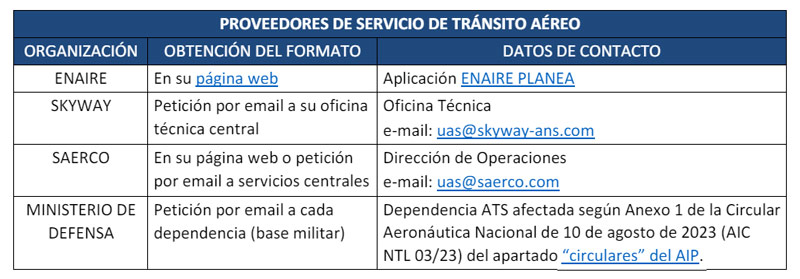
Here you can find a list of airports, aerodromes and heliports in Spain and instructions on how to apply for permits to fly your drone in these areas.
Civil aerodromes for public use and/or military aerodromes other than heliports
- You may fly up to about 45m from the Aerodrome Reference Point (ARP) 6km in each direction of the runway axis extension outwards and 5km on both sides of the runway axis transverse to the extension.
- You can fly from 45m-900m altitude from the ARP 10km extension and 7.5km traverse.
In this article you will find extended information about aeromodelling on the AESA website.
Restricted civil aerodromes which are heliports
- Up to 45m high, from the ARP to 3km from the FATO and 3km wide.
- From 45m-900m altitude, from the ARP to 5km from the FATO and across to 4.5km from the FATO.
Civilian heliports for public use and/or military heliports
- Up to 90m above sea level, from the ARP up to 2.5km longitudinally from the centre of the FATO (Final Approach and Takeoff Area) and 2.5km on a transverse axis from the centre of the FATOO.civilian public use and/or military heliports.
- From 90-900m altitude from the ARP to 3.3km from the centre of the FATO and 3.3km on the transverse axis of the FATO.
Restricted civilian heliports
- Up to 90m in height, from the ARP to a circular area of 2.5km from the centre of the FATO, on heliports with FATOs >100m in length.
- From 90-450m altitude, from the ARP to a circular area of 3.3km from the centre of the FATO, on helipads with FATOs >100m in length.
Professional activities
This distance can always be reduced if agreed by the operator, through a coordination model between restricted use aerodromes and heliports with drone operators (page 17), and if available, with the aerodrome air traffic service provider (ATSP).
These co-ordination documents must always remain at the disposal of AESA, normally the aerodrome is in charge of this co-ordination, at least this has been my experience so far.
No se han encontrado productos.
Controlled Traffic Region (CTR) or in a flight information zone (FIZ)
Recreational activities
This type of operation has NO place in controlled airspace (CTR) and FIZ zone, it will only be possible from infrastructures intended for UAS flight, and whose manager has coordinated the conditions with the air traffic service provider.
Professional activities
The conduct of operations in this area is subject to a number of requirements:
- Operations must always be conducted within the visual line of sight (VLOS) at a maximum height of 60m presenting an EARO (py outside the general or particular UAS geographic zones. This is the great novelty of this new Royal Decree, to be able to fly in CTR without having to coordinate with the ATSP (traffic service provider), to file a flight plan (FPL); but always outside the ATZ (aerodrome transit zone) which is the transit area, a more critical and delicate part.
- Alternatively, if you want to fly outside these limitations while ensuring the safety of the operation, you must be an operator or you will not be able to fly within the ATZs:
- EARO, i.e. Operational Risk Assessment and Mitigation.
- Coordinated with an ATSP (Air Traffic Service Provider). A flight plan (FLP) shall be filed for these operations unless the provider in charge (ENAIRE, Saerco, SKYWAY) does not consider it appropriate.
- Communication and training team. According to article 33.1.e of RD 1036/2017, it is necessary to have radio equipment (walkie-talkie) that allows two-way communication with the aeronautical stations (control tower). It is also mandatory to have the radiophonist certificate with which to accredit the knowledge to properly establish this communication.
I have the Yaesu FTA-550L, and I can say that it is just what I need.

- YAESU FTA-550L Transceptor Banda Aerea 108-136, 200 canales. VOR ,ILS
Flights in prohibited (P), restricted (R), dangerous (D) and sensitive wildlife (F) areas
In order to make a flight, the conditions described in the AIP (points 5.1 and 5.6) and in the ENAIRE DRONES map with which I began the article must be complied with.
All activities carried out in these areas, regardless of the weight of your drone, require prior permission to be granted if it is feasible to fly.
Recreational activities
They may only be carried out unless the competent authority has enabled spaces for this purpose and they are reflected in point 5.5 of the AIP and in the ENAIRE DRONES app.
Professional activities
In order to carry out professional activities, the operator shall comply with the conditions and limitations described in each area and shall have:
- Prior authorisation by the Spanish State for the P areas
- Competent authorities for all other areas (R, D and F)
NOTAM
NOTAMs (notice to airmen) are notices that will allow us to modify the times and/or limits of hazardous areas (D), segregate or temporarily delimit spaces (TSA) and reserve them (TRA). Do you know how to interpret a NOTAM for drones in Spain?
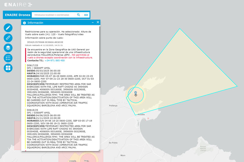
If you want to fly in one of these areas and you want to check the current status to see if there are currently any NOTAMs, you can consult these portals: ICAROXXI of ENAIRE, Enaire Drones map and INSIGNIA.
Environmental zones
The overflight of natural areas (RED Natura 2000 and geographic viewers of the competent Ministry) will always be under the authorisation of the manager of the protected area, always complying with the established restrictions and legislation.
In the ENAIRE DRONES map, these areas are reflected in the layers “protected natural areas” and “special protection areas for birds”.
Photographic flight restricted areas (PFRZ)
The definition is perfectly clear from the title. And they are restricted because they are areas (point 5.7 and in ENAIRE DRONES in the ‘ZRFV’ layer) with protected content, military and reserved areas.
Any activity that involves the taking of photographs or video sequences is subject to what the Ministry of Defence determines, so a prior request must be made to the CECAF (Cartographic and Photographic Centre of the Air Force), which they will provide you with.
Flights over installations affecting national defence and nuclear power plants
Recreational activities
Your question of where you can fly a drone’ has no place here. All flights are strictly prohibited here, including its security zone.
Professional activities
This may only be done with the express prior permission of the Infrastructure Manager.
Flights over/around critical facilities and infrastructure
Recreational activities
Absolutely forbidden. In any case, overflight of chemical, transport, energy and water facilities and infrastructure must be done at a minimum height of 50m, and at a minimum horizontal distance of 25m from their axis (linear infrastructure) and no less than 10m away from their outer perimeter in all other cases.
Professional activities
This may only be done with the express prior permission of the Infrastructure Manager.
Overflight of critical infrastructures are subject to general prohibitions and limitations established in article 32.2 paragraph 2 of the RC 1036/2017, except for those that may be established by the Secretary of State for Security of the Ministry of the Interior on a singular and permanent basis, which will be published in the AIP. More info on critical infrastructures (page 11).
Are you clear on where you can fly a drone and where you can’t?
Do you already know the ENAIRE map, do you think the explanation of the areas where you can fly in Spain is clear, and would you like to add anything? Go ahead, I’ll read you.
Thank you for taking the time to respond and let me know your queries, clarifications or comments.
Bibliography:


9 Responses
Hello. Let’s assume I’d like to fly over town of Nerja, Spain.
Having entered https://drones.enaire.es/ I am getting the information:
“Restricciones para su operación. Ha seleccionado: Altura de Vuelo (m): 120 – Vuelo fotográfico/video
Información sobre punto de vuelo:
364556.777528N 0035203.854439W
Cálculo realizado el 7.08.2024, 21:07:42
Se encuentra en una Zona Geográfica de UAS general por razón de la seguridad ciudadana y la protección de personas y bienes en entornos urbanos.
Por razones de seguridad ciudadana, los operadores de UAS sujetos a la obligación de registrarse deberán comunicar su vuelo previamente al Ministerio del Interior con una antelación mínima de 5 días naturales respecto a la fecha prevista para el inicio de la operación.
Para sobrevuelo o reducción de distancias mínimas a edificios en categoría abierta, se requiere permiso del órgano competente, el titular o administrador responsable del edificio o construcción estable.
ATENCIÓN: Esta aplicación solo debe ser usada para la planificación de vuelos de drones.
Los horarios de los NOTAM son en UTC. Consulte Sistema de referencia temporal en la AIP, GEN 2.1, para más información.
Recuerde que debe seguir cumpliendo con el resto de normativa aplicable.”
I am the registered drone owner and pilot A1/A3 in Poland (EU State).
My drone is C0 category.
What formalities must I go through to be legally able to fly over residential area in Nerja (or any other town)?
1. to register as operator in Spain? https://sede.seguridadaerea.gob.es/sede-aesa/catalogo-de-procedimientos/registro-de-operadores-de-uas ?? [despite the fact I was registered in Poland?}
2. to get a clereance from Spanish Ministry of Interior Affairs? min. 5 days prior to the date of planned fly? Can you pass any details about any form and how to fill it in?
Thank you.
Greg
Hi Gregory,
Answering to your questions:
1. to register as operator in Spain? https://sede.seguridadaerea.gob.es/sede-aesa/catalogo-de-procedimientos/registro-de-operadores-de-uas ?? [despite the fact I was registered in Poland?}
Yes, since last Royal Decree 517/2024 was launched, registration for all drones piloted for non Spanish citizens requieres a full registration in Spain, even though they are registered in their countries abroad.
2. to get a clereance from Spanish Ministry of Interior Affairs? min. 5 days prior to the date of planned fly? Can you pass any details about any form and how to fill it in?
The link to download the documents is right in this article https://javiergomiz.com/en/where-flying-drones-spain/
The only thing is that since you are not Spanish citizens you can’t sign documents electronically, so your way is hand-delivered but you need to be here in Spain.
Don’t forget ZEPA RESTRICTIONS in this area too before flying!!
ZEPA areas
The 100% marine Special Protection Areas for Birds (SPAs/ZEPA), managed by the General Directorate of Biodiversity, Forests and Desertification, have been declared for the protection of seabird species present in our marine waters. These zones can be differentiated into:
Marine zones around breeding colonies: areas adjacent to the colonies, where some species feed during breeding, while others frequent them on their trips in and out of the nest.
Migratory corridors: areas that concentrate the flow of migrating seabirds.
Seabird feeding areas at sea: unrelated to the breeding colonies, these are areas to which birds flock because of the high availability of food.
If you read the ZEPA Area article i showed you you’ll see that recreational flights are forbidden in these areas, that means if you wnat to fly here you have to make it professional, it means you have to pay.
If you need further information and processing drone flight permits, consider my flight permit processing service for these cases.
Let me know.
Javier
Thank you Javier.
It seems there are only few spots on the whole Andalusia coastline to fly free over. It is, to be honest, really disappointing, especially considering common EU rules.
The manual process of gaining clereance is also frustrating. I have no idea what technical barriers are there to justify such approach to tourists.
In my country, Poland, which is considered by many to be “less developed” it is much, much, much easier and the whole process is digital, simply and user-friendly.
I hope some things will change in the future and Spanish authorities reconsider some legal aspects and will be able to present digital environment to simplify UAV flying procedures.
Regards.
Gregory
Hi Gregory,
I completely agree with you, not just tourist but all of us are suffering injustified retrictions and non-sense payments for flying drones in many different places.
The rules just changed a couple of months since a long time ago and it wasn’t for better, so…
Let’s see what future brings us.
Enjoy Nerja and Spain. There must be are something bad in Spain, it couldn’t be perfect 😉
Bests,
Javier
Thank you Javier for your precious contribution in Spain UAV topic.
My last questions are: am I obliged to send the copy of my passport during UAV operator’s registration process?
( I mean – a full scan with face visible)? Should I add there my A1/A3 certificate too?
What about the space for NIF number? May I leave it blank or what should I put there? My polish tax ID?
How long would it take to get spanish operators’ ID? [I’m beginning my visit to Spain on next Monday].
I assume if there is no zone visible on ENAIRE I will be able to fly within the limit of 120m of height? What about the horizontal distanse? How is VLOS described in spanish law? In Poland it is generally 500m distance (it is maximum value you can point in the app in which you have to make check-in before fly).
P.S. Could you please send me directly to mailbox the description of your service. I’m planning to visit Gran Canaria in February and I’m considering hiring someone who can help me with all these procedures.
Regards
Gregory
Gtegory Czy udało Ci się zarejestrować. Strona wyrzuca błędy.
Did you registered successful? I’m getting errors. Often when you move from nif test box.
Hi Daniel,
Due to continuos updates and general unknowledge because of the New Royal Decree 517/2024 about laws and registration, I want to let you all know about a new info update.
I did put in contact to AESA (EASA in Spain) and told me:
If you fly in an open category, you are not required to register your aircraft (only the registration as an operator).
If you are going to fly in a specific category, you will need to register the aircraft, as you will have to make an operational declaration or authorization request, in which you will be required to do so. In this case, you must access the “aircraft” section that you will find by accessing your user (https://sede.seguridadaerea.gob.es/AESA_UAS/). With the registration as a drone operator and aircraf in your country will be ok.
The “inactive” status refers to aircraft that have been included in the profile but are not yet part of an operational declaration or authorization. The moment the aircraft is included in one of these two requests, the status automatically changes to “Auto Accepted”
So after this I’ll change the info inmediatly in my website and I’m sorry for all of this.
Bests,
Javier
Dear Javier,
The information you provide here is indispensable! I continue to learn from all of your writings on the subject, but I have to ask about my general situation, if you don’t mind.
I have a small drone, 150g, class C0, similar to a DJI Mavic Mini. I only intend to fly it on my property below 20m for recreation, but it is in an urban area with no other restrictions, according to the Enaire map. (El Tosalet urbanization in Javea, Alicante province).
1) Assuming I register myself (I am a Spanish resident), and I am familiar with the craft (I know it is recommended to get the A1 certificate), can you confirm no insurance is required as mentioned in the article here (https://www.seguridadaerea.gob.es/es/ambitos/drones/operaciones-con-uas-drones/operaciones-con-uas-drones—categoria-abierta-subcategorias-a1-a2-y-a3)? I have read other sources indicating insurance is always necessary, but this page seems to indicate it is not.
2) Given that I only want to fly on my own property below 20m, though in an urban area, and in the subcategory as you’ve mentioned in this article, “A1 with UAS of class C0. UAS of strong, altitude of 20m. No minimum horizontal distance is established for this type of aircraft.”, is it still required to provide the 5 days notice?
Thank you in advance for taking the time to respond.
Nick
Hi Nick,
Thanks for questions, answering them:
I hope it helps,
Feel free to invite me a Ko-fi at the end of the article for my time and given help 😊
Javier