Drone photogrammetry is a technique that uses drones equipped with cameras or other sensors to collect aerial images from different angles and heights.
Remember that if you purchase a drone with a device that captures images and you want to do photogrammetry, you are (almost certainly) required by law to register as a drone operator. Check it out before starting your aeronautical operation in my article on the 5 requirements to fly a drone in Spain.
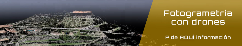
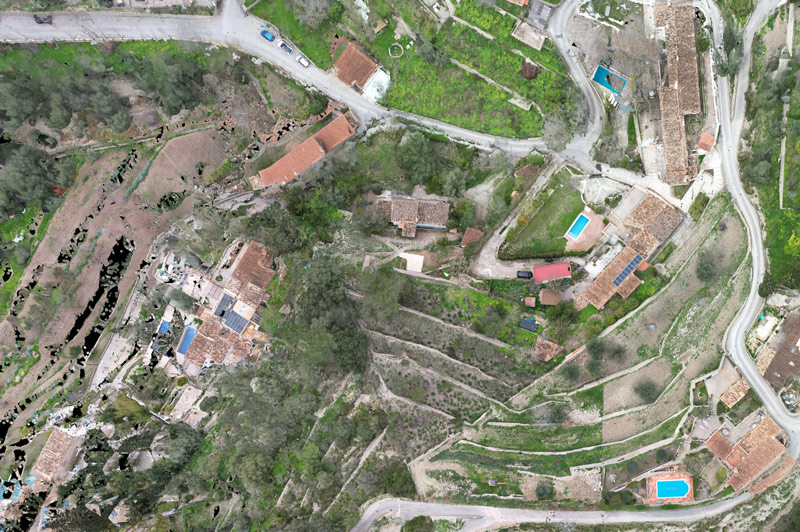
Photogrammetry with drones for the construction sector in Mallorca
In the field of construction and surveying, accurate and up-to-date terrain data is key to efficient project planning and execution. Drone photogrammetry allows 3D models, orthomosaics and high-precision topographic maps to be obtained, reducing time and costs compared to traditional methods.
In Mallorca, we offer professional photogrammetry services using drones for construction companies, architects, quantity surveyors, engineers and draughtsmen. This provides detailed information for preliminary studies, volumetric calculations, urban planning and construction monitoring.
Thanks to high-resolution aerial imaging, we guarantee accurate measurements, optimising land analysis, irregularity detection and construction project management.
If you are looking for a professional and efficient photogrammetry service in Mallorca, do not hesitate to contact us.
What is photogrammetry?
Drone photogrammetry is a technique based on the principle of triangulation, which uses between 125 and 150 photographs (minimum to achieve good results) taken from different points of view to measure and create 3-D representations of surfaces or a given object made with UAS.
The different types of drones, or unmanned aerial vehicles (UAVs), have opened up an incredibly wide field and offered new possibilities for accurate three-dimensional modelling. They have reshaped the rules of the game, for example, in surveying activities such as a civil works survey.
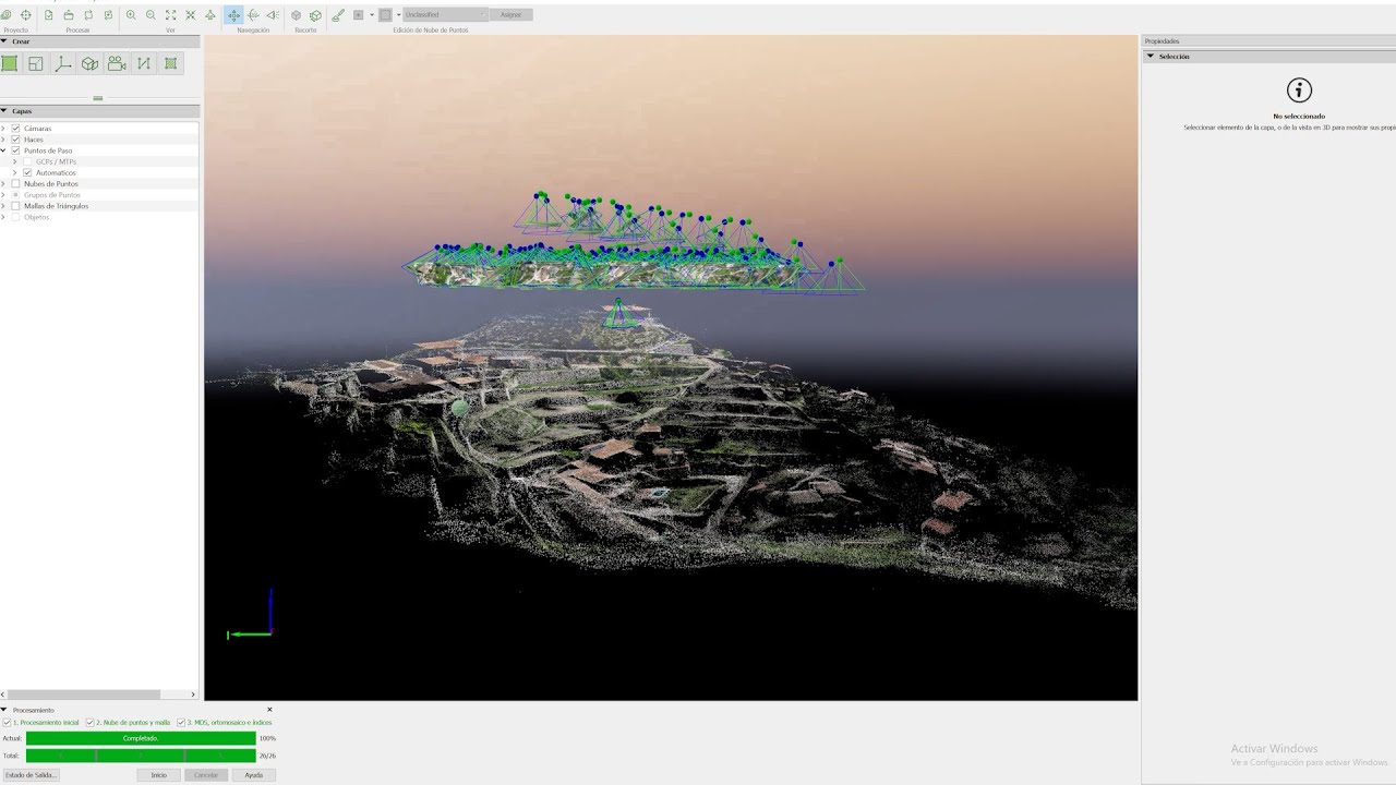
This technique of capturing geospatial data has undergone a significant transformation with the advance of drone technology, which allows images to be captured from different positions and heights, thus obtaining a greater amount of information in a more precise, controlled and rapid manner.
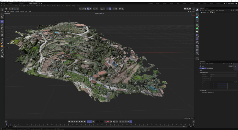
These images, with the help of professional software and in-depth knowledge, are processed to create accurate and detailed three-dimensional (3D) models with the aim of studying and precisely defining an area or the shape, dimensions and spatial position of an object or motif.
Professional drones for 3D photogrammetries
Nowadays with any drone over 300€, thanks to powerful software and applying the right technique, you will get very good results.
However, if your goal is to achieve professional photogrammetry with drones, I suggest drones like the Mavic 3 Enterprise and the high-end drones with RTK if you need to achieve more precise photogrammetry and more accurate measurements.
| # | Preview | Product | Price | |
|---|---|---|---|---|
| 1 |

|
OSCAL Estación de Energía Portátil, 6000W… | 2.099,99 EUR | Buy on Amazon |
| 2 |

|
DJI Pack Básico de Tranquilidad – Mavic 3T (C2) -… |
4.919,00 EUR |
Buy on Amazon |
| 3 |

|
DJI Mavic 3 Pro Cine con el Mando a distancia DJI… | 3.629,00 EUR | Buy on Amazon |
Having a GPS on the ground to give you supporting geolocations could be another good option.
It is important to do thorough research and compare the features of each drone to ensure you purchase the right device for your drone photogrammetry project.
(Probably) The best drones for photogrammetry
I don’t know if these drones are the best drones for photogrammetry, but I am sure that with any of them you will be able to achieve more than good results.
- The Mavic 3 Pro Enterprise performs advanced photogrammetry and aerial mapping tasks. Hasselblad HR camera, 4/3 sensor that can generate accurate 3D models and orthophotos. Includes high-precision GPS, RTK. 45-minute flight time, omnidirectional sensors recommended for surveying, precision agriculture, and infrastructure monitoring.
- DJI Mini 4 PRO: The DJI Mini 4 PRO is a drone that can be flown without a licence in cities and towns, although you are still required to notify the relevant Ministry of the Interior. It is foldable, ultra-lightweight, has a camera with up to 48MP and 4K recording, and 34 minutes of battery life. Like the DJI Air 3, it has waypoints, which are useful for plotting a route, making flying easier and helping to save battery power. The measurements are not as reliable as those of a drone with RTK.

- DJI Mavic 2 Pro: We always come back to the great DJI Mavic 2 Pro. This high-end drone features the famous 20 MP Hasselblad camera, a 1″ CMOS sensor, 4K, 31′ flight time, and 8 km video transmission. Intelligent flight modes and omnidirectional obstacle detection. One of the best options for professional drone photography and videography.
- DJI Mavic Air 2s: Dron plegable y portátil, cámara de 20 MP, sensor CMOS de 1″ que graba vídeo en 5.4K. Autonomía de vuelo de 31′ y un rango de transmisión de 12km. Vuelo inteligentes y detección de obstáculos omnidireccional. It is one of the best drones of 2023 for creative photo and video. Versatile and powerful as it0 is.
- MAVIC 3M: Combines an RGB camera with four multispectral cameras. It has a 20 MP 4/3 CMOS RGB and RTK (satellite positioning) camera. Suitable for precision agriculture, as you can see in the following video.
Remember that by purchasing some of these products, for you at no extra cost from these links, you help to maintain my website, Javier Gómiz, and to continue offering you the best information about photography and video with drones.
Process and steps for photogrammetry with drones
This image capturing technique is very similar to the process of panoramic photography, and like panoramic photography, if you want to know how to get a good photogrammetry, I recommend you to follow the steps below:
Pre-flight photogrammetry
- RAW images: If we are looking for maximum quality, although I must say that in JPEG, and depending on the settings we use when taking the photo, we can also obtain good results.
- Weather conditions: We will look for cloudy but bright days to avoid harsh shadows and achieve softer, more even lighting throughout our scene. Check the Windy website and you will be able to see the weather forecast and organise your flights efficiently.
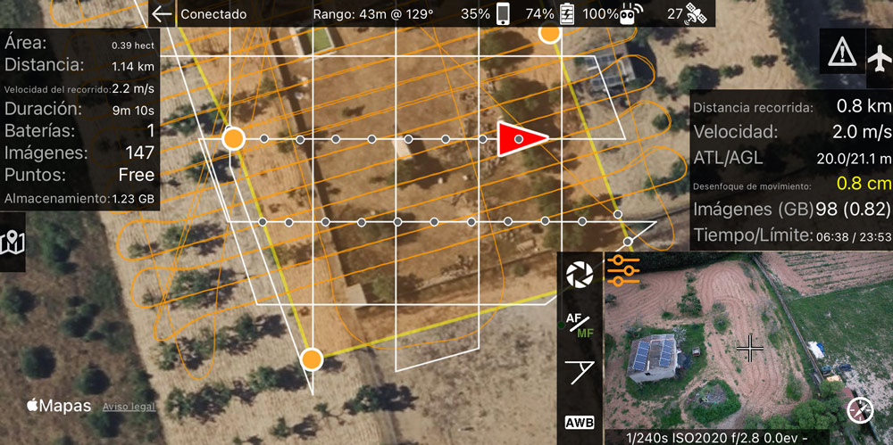
- Image acquisition correlation: Try to take the images in a correlative way looking for at least 80% overlap between image and image, this will make it easier for the software to assemble 3D images during rendering.
- Scheduled flights: If you need to do professional photogrammetry with drones to get more precise and accurate technical details and specifications, I recommend you:
- Use drones with RTK as mentioned above.
- Use apps to plan flights: Litchi, Pix4Dcapture Pro, Made Maps Easy (the one I use, which offers a 15-day free trial to try out all the Premium options), Dronelink, etc. Flighthub 2 is the professional DJI app we work with at MIRAI. It’s amazing what you can do with this app. All of these apps require payment.
- Correct camera settings:
- White balance between 5200-5700 (for this type of cloudy day), but always fixed and not automatic.
- Highest quality resolution of photographs
- Use 4:3 aspect ratio and avoid wide-angle shots that tend to distort edges and corners.
- Make sure each photo is in focus before shooting, or if shooting automatically with flight planners, find the focus on the first photo.
I show you some interesting tricks to take good photos with drones where you will learn the right settings to get the most out of your drone.
Post-flight photogrammetry
- Image processing: The images we have captured are downloaded and processed with special software for photogrammetry, which I will talk about in the next point.
- Generation of the 3D model: What is commonly called the rendering of the photographs. Here the images are matched and a 3D model of the area or object of interest is generated.
- Analysis and application: Once the 3D model is generated, it can be used for different analyses and applications as I will tell you a little later.


Best free software for photogrammetry with drones
Here are the best free programmes for 3D photogrammetry with drones:
- Meshroom
- Regard3D
- Colmap
- OpenMVS
- VisualSFM
There are also paid software and programmes for photogrammetry with drones, which offer more advanced features that may be of interest to us when developing our photogrammetry project with drones:
- Agisoft Metashape
- Pix4Dmapper
- RealityCapture
- PhotoScan de Agisoft
- 3DF Zephyr de 3Dflow
- ContextCapture de Bentley Systems
Once you have obtained your 3D photogrammetry with any of these programmes, you can use programmes such as 3D MAX or AUTOCAD to finish it, but this is another story that will have to be told on another occasion.
If the purpose of your project is to isolate a certain object and you want to apply an environment or scenery to it, you can use other programs such as Lumion or Blender.
Finally, to obtain our playback file, I advise you to import all the material obtained so far into video editing programmes such as Premiere or Da Vinci.
Applications of photogrammetry with drones
I will tell you which are the most common in everyday life:
Cartography and topography
3D photography allows the creation of high-precision and high-resolution topographic maps and orthophotos. These maps are used for urban planning, natural resource management, natural disaster risk assessment, infrastructure management, among other applications.
By taking a professional drone pilot course in photogrammetry and topography, you will gain the knowledge and skills to plan, carry out and produce photogrammetric and topographic data of the scenarios you want.
Precision farming
Drones equipped with multispectral cameras can capture images of crop fields at different wavelengths. This allows you to analyse and monitor plant health in real time. It therefore helps you to detect diseases early, optimise irrigation and fertiliser application, and make decisions to improve agricultural productivity.
By taking a professional drone pilot course in precision agriculture you will acquire knowledge and skills in the early detection of the condition of different types of crops using drones.
Infrastructure inspection
3D drone photogrammetry can be used for the inspection of bridges, roads, railways, power towers, buildings and other structures. Drones can safely access hard-to-reach areas and capture images that enable defect detection, structural condition assessment and maintenance planning.
If you are looking for a professional technical inspection course that also teaches you how to use software such as Pix4D.
You will acquire the knowledge and skills necessary to analyse wind farms, power lines, solar panels, and telecommunications towers with the help of your drone. Then, in post-production, you will create these three-dimensional 3D models, orthophotos, etc.
Architecture and construction
3D models generated from 3D drone photogrammetry can be used in design planning, project visualisation, construction feasibility assessment and monitoring the progress of a construction site.
Tourism and cultural heritage
3D drone photogrammetry can be used for the documentation and preservation of archaeological sites, monuments, cultural heritage and tourist attractions.
Environment and conservation
Drones equipped with high-resolution sensors can capture images of protected natural areas, wildlife habitats and fragile ecosystems. This allows monitoring of the environment, identification of changes in vegetation, detection of endangered species and planning of conservation actions.
Advantages of aerial photogrammetry over traditional photogrammetry
The advantages are clear, and to my mind quite obvious, such as:
- Speed and efficiency in data capture
- Ease of access to hard-to-reach areas.
- Image capture security. You will avoid physically exposing yourself to situations in which taking a photo could be dangerous.
All this makes drone photogrammetry an interesting, valuable and fundamental tool in many sectors.
Expert in photogrammetry with drones
Severino Martínez is one of the leading experts and benchmarks in drone photogrammetry in Spain. He has some very interesting work that may enlighten you in this emerging world of drone photogrammetry.
I invite you to see the work of Severino Martínez in the interview that Rafa Ocón did with him in Droneguru.
What do you think about photogrammetry with drones? Did you know this technique? I read you!